

 Last weekend, Google released an update to its iPhone map application, “Google Maps.”
While each update undoubtedly makes the system more convenient, this latest update includes a welcome feature that could be said to render a built-in navigation system in a car unnecessary.
"Using your smartphone for navigation? The screen is too small to see clearly, and the amount of information isn't reliable, right?" That's what I often hear. But I haven't used a built-in navigation system for nearly five years now, and I handle everything using only smartphone navigation apps.
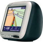 Eight years ago, I had the opportunity to travel around the United States by car every day. Initially, I thought a map would suffice, so I bought a local map at a bookstore and planned to travel while checking key locations, but on the first night, I happened to see...I saw a TV commercial for Best Buy (a major American electronics retailer) announcing the release of a car navigation system called “TomTom Go 300,” and thought, "Maybe I really need a car navigation system," so I bought it the very next day. It has a small 3.5-inch monitor, but it has a built-in speaker, a reasonably responsive touchscreen that's easy to use even while driving, and it even comes standard with Bluetooth. I've forgotten the exact price, but I think it was around $3.I don't think it was even 00.
 The TomTom Go 300 was incredibly user-friendly. To be honest, driving alone with just a map in hand through the complex interchanges of major American cities and places like Manhattan, where yellow cabs are zipping around in a grid pattern, was practically impossible. So, I did some research on TomTom while I was in the US. I discovered that TomTom had released a navigation app for smartphones. At the time, neither iOS nor Android existed (or rather, they weren't available on the market), and Windows Mobile or Symbian were the mainstream for smartphones, but TomTom had released a navigation app for Windows Mobile smartphones. I was using Symbian (Motorola M1000) at the time, so I had to give up on getting it, but later I got a Windows Mobile (HTC Hermes) and installed the app, and it was just as easy to use as the TomTom Go 300. From then on, I thought, "If I have a smartphone, I don't need a built-in navigation system anymore."
A few years later, Google announced the “HTC G1” running Android OS and released “Navi” as a smartphone app. I was very surprised that a free smartphone navigation app was available. Initially, it only supported navigation on US maps, but eventually it also supported Japanese maps, and it has been continuously improved to what it is today.
There was a time when the poor usability of the default “Maps” app installed on iPhones was a hot topic, but it has since been significantly improved. However, it's undeniable that it still falls short of the vast amount of information available on Google Maps. When considering practical navigation uses, such as including or excluding toll roads when searching for a route, Google Maps still feels more valuable.
The new feature implemented in this update is that, while navigating the route to your destination, it will display alternative routes that can shorten the travel time, depending on traffic conditions and other factors.
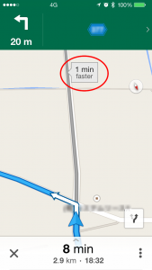
... "The initial route selection involved turning left, but going straight will allow us to arrive one minute earlier."
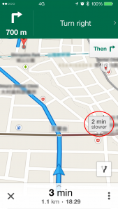
... "Instead of going straight at the next traffic light, turning right will cause you to arrive at your destination two minutes later."
Even better, it's equipped with an offline maps function that allows you to view maps even in areas without a signal.
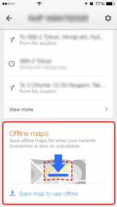
The system allows you to search for and save a route in advance where you have internet access, and then it will navigate you to your destination.
Unfortunately, this offline maps feature doesn't seem to be available in Japan yet, but it will probably become available in the future.
(The current latest version of Google Maps for iPhone is 3.0.1)